Concerns have recently been raised in Europe about the preservation of the national cultural heritage. Lithuania is no exception.
Place names are one of the elements of the intangible cultural heritage. At the end of 2014, a dataset of Lithuanian place names was created by order of the National Land Service under the Ministry of Agriculture, for the collection and management of settlement name data of the territory of the Republic of Lithuania. The set of place names is provided at Geoportal.lt at the address https://www.geoportal.lt/vietovardziai publicly and free of charge. Help material on how to use the service is available here: https://www.geoportal.lt/extra-services-webapp/views/gvdr/serviceInfo.xhtml
The need for a unified set of Lithuanian place names
Place names are inseparable from the geographical objects they name. When objects disappear, are rearranged or destroyed, but the information is not collected about them, their names in living use may disappear or be distorted.
The reasons for changing or disappearing place names vary. In the last century, the change of place names in the territory of Lithuania was mainly related to changes in the landscape due to mass collectivization, land reclamation, land occupation and Sovietization. The disappearance of place names is now linked to demographic change in the country.
When Lithuanian villages are emptied, homesteads collapse or for other reasons, decisions are made to unite or destroy the villages. According to the data of the Center of Registers, in the last five years, 240 villages have been taken out of the registry. The scale of street name changes is even greater.
The need for a collection of place names in Lithuania is indicated by the fact that there are objects (rivers, lakes, ponds; boulders; islands; city sculptures, monuments, etc.) that do not enter state registers and cadastres due to their characteristics (for example, small size). Information about such objects, as well as their names, is not systematically collected. Another problem is that the information about old Lithuanian place names accumulated in various data sources (dictionaries of place names, ethnographic resources stored in libraries, etc.) is often only approximately related to the place information or not related at all. For convenience, residents still name unnamed or complex objects with official names in some way. It is therefore important to create the preconditions for the proper and standardized use of geographical object names in the press, radio, television and other public use. (Example of distorted usage: Simonas Daukantas pedestrian bridge over the Nemunas in Kaunas after the impressive flight of the pilot Jurgis Kairys under the bridge was mistakenly called the Kairys Bridge by city residents and guests.) Thus, the need for the collection of Lithuanian place names was high. The most suitable conditions for its creation are at Geoportal.lt, where geographical data is collected using the principles of geoinformation systems.
Place name data and sources
The collection of Lithuanian place names provided through Geoportal.lt contains data from various data sources. A complete list of data providers can be found here: GV_DRLT data sources .
In total, the dataset contains more than 100,000 place name objects.
The set of place names can be expanded to include data from other data sources, after agreeing on legal issues with data controllers.The principles of geographic information systems are applied to work with the collection of Lithuanian place names. Place name objects are stored in different layers of information like points, lines, and areas. In accordance with the requirements of the European Spatial Information Infrastructure Network (INSPIRE) Geographical Names Specification (hereinafter - the specification), the names of place names are divided into certain types, the attributes of the objects are distinguished. In addition, additional attributes have been created for national purposes (allowing location names to be printed and standardized). All place name information is provided online and accessible to every user. Registered users have access to various opportunities to work with the Lithuanian place name set. We invite to watch a video (in Lithuanian) on how to practice to use the data set of place names provided through geoportal.lt.
Opportunities and tools
The tools created at Geoportal.lt help to find a place name of interest by name, its part or object territory. You can view the found place names on the map, find out detailed information about them (currently a small part of the objects have such information, the information is still being collected). Inaccuracies or shortcomings found can be reported to the manager of the collection of Lithuanian place names using specially designed tools. In addition, tools have been developed for the approval of place names.
The collection of Lithuanian place names can be useful in various cases.
By defining the area to be analyzed around an unnamed geographic feature (e.g., street, residential neighbourhood, business), it is easy to find existing or former place names in that region and find ideas on how to create a new feature name.
In order to find place names of the same origin or structure next to the object of interest, it is necessary to define the analyzed area around the object of interest and specify a word fragment in the search window. In this way, it is possible to find settlements whose name could be derived from the name of the lake. For example, by drawing a circle with a radius of 500 meters around Lake Pusnė (Molėtai district), the village of Pusnė is also found (Fig.).
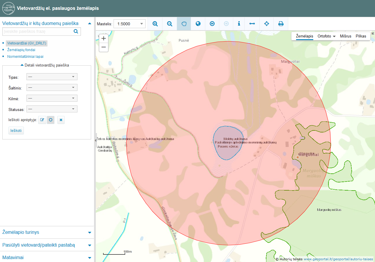
Fig. Possibilities of searching for hydronyms located around the lake of interest in the collection of Lithuanian place names
In the area of interest, place names can be used to search for a former or current object. For example, under the names; Malūno St. Ligoninės St. and so on. It is possible to search for an existing or former mill, a hospital. From the place names of personal origin, it is possible to trace the twists and turns of the history of Lithuanian national minorities in Lithuania. For example, the names Torklerio malūnas (Torkler Mill), Vižanskio malūnas (Vižanskis Mill) are signs of Jewish history in Virbalis (Vilkaviškis district).If necessary, additional maps can be uploaded to the portal, thus expanding the possibilities of analyzing place names. For example, in order to more precisely mark the old place names of forests and wetlands in the vicinity of Sariai village in Švenčionys district, it is possible to upload the topographic map of 1950 M1: 25000.
Thus, data on Lithuanian place names are increasingly available on the Internet in various places. The collection of Lithuanian place names provided through Geoportal.lt is the place where place names started to be collected by integrating different source name sources, giving data providers the opportunity to collect place names and those objects that do not fall into data registers and information systems. The built-in workspace allows you to upload place names, analyze, map, normalize.